Railways in the Morley District

Menu
Much of the Morley district is on the ridge between the Aire and Calder Valleys with the majority well above sea level. Prior to the railway era, roads leading to Morley which were on the ridge were reasonable but not those coming from Leeds, Batley and Dewsbury.
By the 1840s, Railway mania had captured the imagination of the country due to the speed of the transport and the number of people or goods that could be carried.
But the hilly nature of Morley was a major stumbling block in any railway system which connected it to Leeds and the Pennine towns.
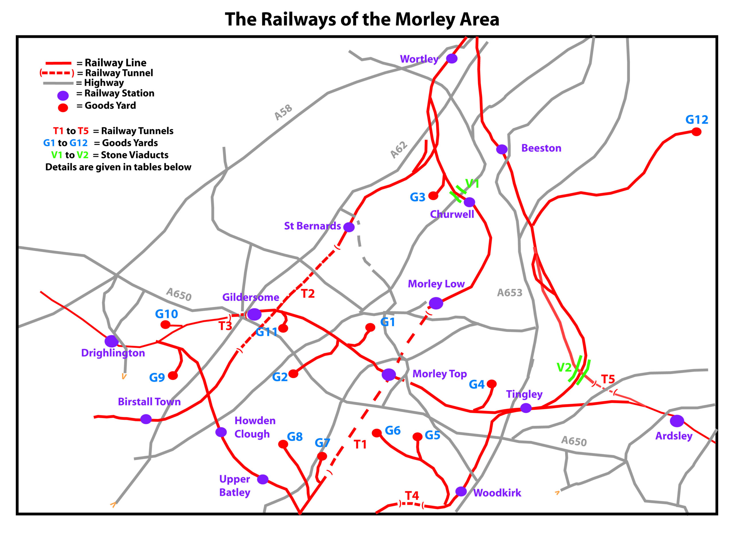
Such were the rewards that a plan was in fact conceived quite quickly to set up such a system. The plan needed a big viaduct from Churwell and a tunnel, just under 2 miles long to enable a line from lower Morley and Howley which travelled under the hilly town. It needed over £225,000 to finance (around £19.5m in today’s prices) and took 2 years to open in 1848. Certain details of the project are hard to come by but we will detail those we have in the near future..
Less than 10 years later, riding on the railway boom, a considerably easier link was established between Bradford and Wakefield which took in Drighlington, Gildersome, Morley (at a new station), Tingley and Ardsley.
Thereafter, other lines were added to this basic network as these advantages came to be clearly seen.
The impact on local trading of raw materials (coal, wool and cotton) and finished articles (mainly cloth) and accessibility of the surrounds was great, enabling local people to travel much greater distances than previous.
This continued until the 1960s when road transport began to erode the advantages of the railway and there was then a massive decline over the next 30 years so that now only the initial line remains in its original form.
The Lines
| Line | Company | Opened | Status |
| Leeds-Morley Low-Morley Tunnel-Dewsbury | Leeds, Dewsbury and Manchester | 18/09/1848 | Still Active |
| Bradford-Drighlington-Gildersome-Morley Top-Ardsley | Leeds, Bradford and Halifax Junction | 10/10/1857 | Closed 04/07/1966 |
| Holbeck Jctn-Dunningley viaduct-Ardsley Tunnel-Ardsley-Wakefield | Bradford, Wakefield and Leeds | 05/10/1857 | Leeds-Wakefield link electrified in 1989 after station closures in 1966. |
| Adwalton-Howden Clough-Batley | Leeds, Bradford and Halifax Junction | 19/08/1863 | Closed 07/09/1964 |
| Batley-Soothill Tunnel-Woodkirk-Tingley-Beeston | Great Northern Railway | 01/08/1890 | Closed 29/10/1951 |
| Spen Valley-Birstall-Gildersome Tunnel-St Bernards-Farnley | Great Northern Railway | 01/10/1900 | Closed 02/08/1963 |
| Return to Menu |
The Tunnels
Map | Tunnel | Length | Opening | Present State |
|
T1 |
Morley Tunnel |
1mi (3.07 Km) |
1848 |
Still used |
|
T2 |
Gildersome Tunnel |
1.yyy Miles (2.13 km) |
1900 |
Abandoned |
|
T3 |
Gildersome Street |
0.07 Miles (0.14 Km) |
1857 |
Filled in |
|
T4 |
Woodkirk (Soothill) |
0.4 Miles (0.6 km) |
1890 |
Abandoned |
|
T5 |
Ardsley |
0.14 Miles (0.27 Km) |
1857 |
Used again after the Leeds-Wakefield Line was electrified in 1989. |
| Return to Menu |
Stone Viaducts and Overhead Railway Bridges

View from Bridge Street as a train approaches Morley Top Station 
Railway bridge over Bruntcliffe Lane
In the original line linking Leeds with the Pennine towns a viaduct was needed at Churwell along with bridge work in the Leeds area. Another viaduct was necessary at Dunningley when the Leeds Wakefield line was constructed. This is no longer used but its skeleton survives as can be seen in the YouTube video referrred to later.
One viaduct, going over Bridge Street and High Street was needed locally when Drighlington and Ardsley were connected and the numerous highways in this area necessitated more railway bridges. The track went over the highway in most cases but that on Fountain Street was an exception, giving local schoolboys a great opportunity for train-spotting.
Goods Depots
Map | Depot | Existence |
|
G1 |
Robin Hood Quarry – Scatcherd Park |
Stopped 1929 |
|
G2 |
Victoria Colliery – Bruntcliffe |
1857-1930 (mine closure) |
|
G3 |
Tanhouse Colliery – Churwell |
1893 – closed after a strike |
|
G4 |
Topcliffe Colliery – Tingley Gas Works – Tingley |
1860-1928 (mine closure) 1948-1970 (site closure) |
|
G5 |
Britannia Quarry – Woodkirk |
1892-1964 |
|
G6 |
Howley Park Quarry |
1892-1964 |
|
G7 |
Howley Park Colliery |
1920c |
|
G8 |
West End Colliery |
1945c |
|
G9 |
Howden Clough Colliery |
1933c |
|
G10 |
Wire Hall Colliery – Adwalton |
1906c |
|
G11 |
Hudson’s Foundry – Gildersome |
1865-1966 |
|
G12 |
Hunslet – Goods Branch |
1899-1967 |
| Return to Menu |
For the sake of clarity, the following Goods depots were omitted from the map
Station | Depots | Existence |
|
Morley Low |
Goods Depot; Morley Gasworks; Morley Main Colliery |
1848-1959 1848-1948 (works closed) 1855-1909 (mine closure) |
|
Morley Top |
Goods Depot |
1857-1969 (station closed) |
|
Ardsley |
Goods Depot Ardsley Ironworks East Ardsley Colliery |
1857-1969 1860-1929 (works closed) 1872-1968 (mine closure; the last in the district) |
|
Gildersome |
Goods Depot |
1857-1966 |
|
Drighlington |
Goods Depot |
1857-1966 |
We have used the thorough research of A.J. Haigh extensively in compiling this article.
The group AdventureMe has done a number of YouTube videos of sections of the Morley Railways including Ardsley Station, the Dunningley Viaduct and Tingley, and Gildersome and Drighlington Stations. These can be found by searching YouTube and that made for Morley Top Station is shown below:
Present Day view of the Morley Top area
Present Day view of the Gildersome and Drighlington Station areas
Present Day view of Tingley Station and Dunningley Viaduct on the way to Beeston
Present Day view of Ardsley Station


You must be logged in to post a comment.